A Radar Image of Planet Earth
Credit: NASA, JPL Imaging Radar Program
Discover the cosmos! Each day we feature a different image or photograph of our fascinating universe, along with a brief explanation written by a professional astronomer.
August 24, 1995
A Radar Image of Planet Earth
Credit: NASA,
JPL Imaging Radar Program
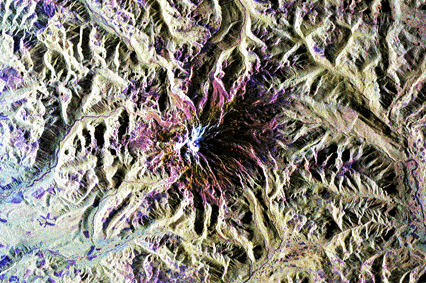
Explanation: This image of Mt. Rainier, Washington USA, planet Earth, was produced by the Spaceborne Radar Laboratory which flew on the Space Shuttle Endeavour in 1994. Radar, short for RAdio Detection And Ranging, is a technique which coordinates the operation of a radio transmitter and receiver to measure the direction, strength, and timing of radio echos from the surface of distant objects. An actual image of an object can be constructed by recording and analyzing many echos. One advantage of using radar imaging in planetary studies is that images can be made regardless of cloud cover or lighting conditions. During the early 90s, NASA's Magellan spacecraft was able to use radar imaging to produce similar high resolution maps of the surface of Venus.
For more information about the picture click here.
Tomorrow's picture: A World Explorer

We are proud to acknowledge that an external review by
Point Communications
has rated Astronomy Picture of the Day in the top 5 percent of all
World Wide Web sites.