 |
Astronomy Picture of the Day |
| |
Astronomy Picture of the Day |
 APOD: 2026 June 27 – Mars Marathon by Perseverance
Explanation:
In this recent HiRISE
view from the Mars Reconnaissance Orbiter,
the little green dot indicated on the surface of the big Red Planet is the
Perseverance
Mars rover.
Recorded on June 13, the car-sized, six-wheeled robot was imaged
a day before completing a Martian marathon,
traveling a total distance of 26.218 miles
(42.195 kilometers)
since it began exploring the surface of Mars.
That equivalent marathon distance was achieved by Perseverance on its
mission sol (Martian day) 1,890, after about 5 Earth years
and 4 Earth months of driving.
Perseverance is continuing to hunt
for biosignatures.
In the HiRISE image, the Mars rover's tracks
can be seen leading to
its location
in an area west of its
landing site in Jezero crater near an
ancient river delta.
 APOD: 2026 January 25 – Phobos: Doomed Moon of Mars
Explanation:
This moon is doomed.
Mars,
the red planet named for the
Roman god of war, has two tiny moons,
Phobos and
Deimos, whose
names are derived from the Greek for Fear and
Panic.
These Martian moons may well be captured
asteroids
originating in the main
asteroid belt between Mars and
Jupiter
or perhaps from even more distant reaches of
our Solar System.
The larger moon, Phobos, is indeed seen
to be a cratered, asteroid-like object in this
stunning color image from the robotic
Mars Reconnaissance Orbiter,
which can image objects as small as 10 meters.
But Phobos orbits
so close to Mars - about 5,800 kilometers above the
surface compared to 400,000 kilometers
for our Moon - that gravitational
tidal forces are dragging it down.
In perhaps 50 million years,
Phobos is expected to disintegrate
into a ring of debris.
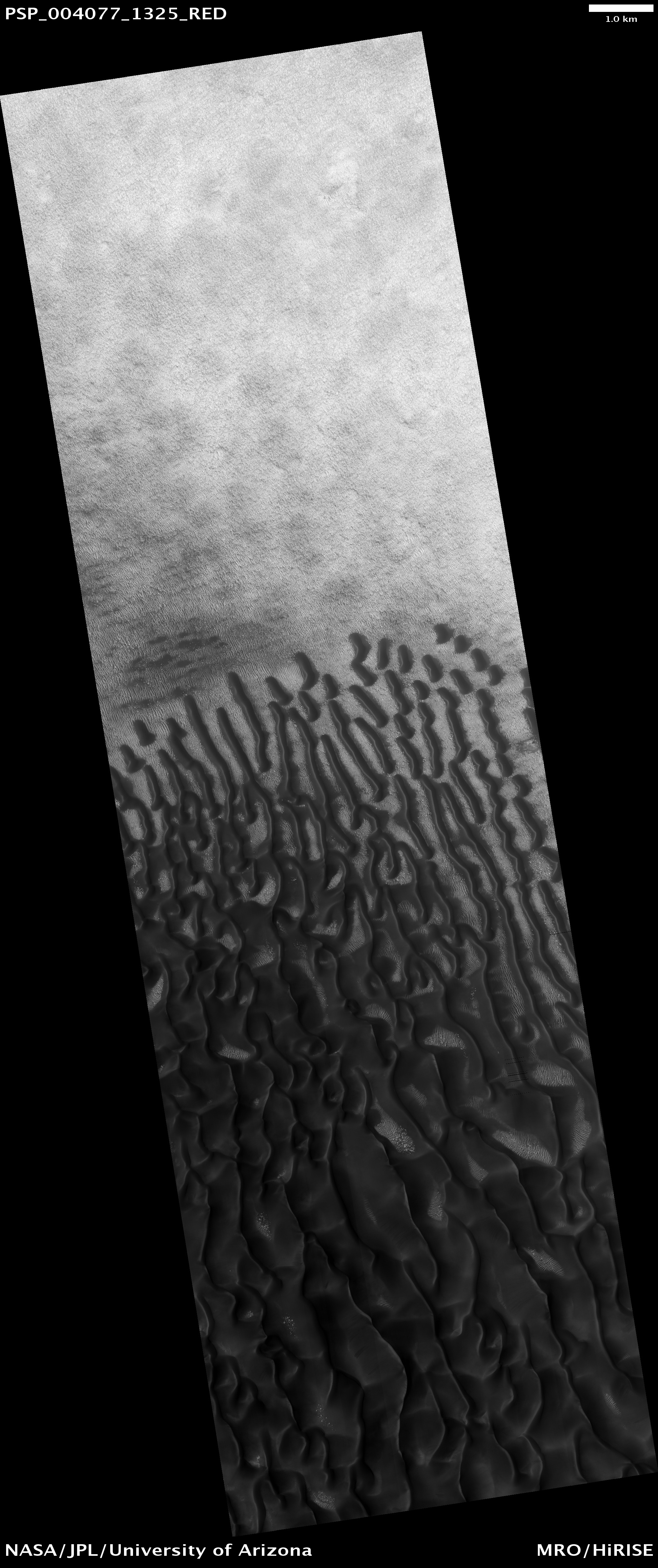
 APOD: 2025 June 29 – Dark Sand Cascades on Mars
Explanation:
Are these trees growing on Mars?
No.
Groups of dark brown streaks have been photographed by the
Mars Reconnaissance Orbiter on melting pinkish sand dunes covered with light frost.
The featured image was taken in 2008 April near the
North Pole of Mars.
At that time,
dark sand on the interior of
Martian sand
dunes
became more and more visible as the spring Sun melted the lighter
carbon dioxide ice.
When occurring near the top of a dune,
dark sand may cascade down the dune leaving
dark surface streaks -- streaks that might appear at first to be
trees standing in front of the lighter regions but cast no shadows.
Objects about 25 centimeters across are resolved on
this image spanning about one kilometer.
Close ups of some parts of this image show
billowing plumes
indicating that the
sand slides were occurring even
while the image was being taken.
 APOD: 2025 May 17 - Ares 3 Landing Site: The Martian Revisited
Explanation:
This close-up from
the Mars Reconnaissance Orbiter's
HiRISE camera shows weathered craters and windblown deposits in southern
Acidalia Planitia.
A striking shade of blue in standard HiRISE image colors,
to the human eye the area would probably look grey or a little reddish.
But human eyes have not gazed
across this terrain, unless you count the eyes of NASA astronauts
in the sci-fi novel,
"The
Martian,"
by Andy Weir.
The novel chronicles the adventures of Mark Watney,
an astronaut stranded at the fictional Mars mission Ares 3 landing site,
corresponding to the coordinates of this cropped HiRISE frame.
For scale, Watney's 6-meter-diameter habitat at the site would be
about 1/10th the diameter of the large crater.
Of course,
the Ares 3 landing coordinates are only about 800 kilometers north of
the (real life) Carl
Sagan Memorial Station,
the 1997 Pathfinder landing site.
 APOD: 2024 September 7 - Small Moon Deimos
Explanation:
Mars has two tiny moons, Phobos and
Deimos,
named for the figures in Greek mythology Fear and Panic.
Detailed surface views of smaller moon Deimos are shown
in both these panels.
The
images were taken in 2009,
by the HiRISE camera on board the
Mars Reconnaissance Orbiter
spacecraft, NASA's long-lived
interplanetary internet
satellite.
The outermost of the two Martian moons,
Deimos is one of the smallest known moons in the
Solar System, measuring only about 15 kilometers across.
Both Martian moons were discovered in 1877 by
Asaph Hall,
an American astronomer working at the
US Naval Observatory in Washington D.C.
But their existence was postulated around 1610 by
Johannes Kepler,
the astronomer who derived the laws of planetary motion.
In this case, Kepler's prediction
was not based on scientific principles, but
his writings and ideas were so influential that the two Martian moons
are discussed in works of fiction such as
Jonathan Swift's
Gulliver's Travels,
written in 1726, over 150 years before their discovery.
 APOD: 2024 March 23 - Ares 3 Landing Site: The Martian Revisited
Explanation:
This close-up from
the Mars Reconnaissance Orbiter's
HiRISE camera shows weathered craters and windblown deposits in southern
Acidalia Planitia.
A striking shade of blue in standard HiRISE image colors,
to the human eye the area would probably look grey or a little reddish.
But human eyes have not gazed
across this terrain, unless you count the eyes of NASA astronauts
in the sci-fi novel,
"The Martian",
by Andy Weir.
The novel chronicles the adventures of Mark Watney,
an astronaut stranded at the fictional Mars mission Ares 3 landing site,
corresponding to the coordinates of this cropped HiRISE frame.
For scale, Watney's 6-meter-diameter habitat at the site would be
about 1/10th the diameter of the large crater.
Of course,
the Ares 3 landing coordinates are only about 800 kilometers north of the
(real life) Carl
Sagan Memorial Station,
the 1997
Pathfinder landing site.
 APOD: 2023 July 8 - Stickney Crater
Explanation:
Stickney Crater, the largest crater on the martian moon Phobos,
is named for
Chloe Angeline Stickney
Hall,
mathematician and
wife of astronomer Asaph Hall.
Asaph Hall discovered both the
Red Planet's moons in 1877.
Over 9 kilometers across, Stickney is nearly half the
diameter of Phobos itself, so large that the
impact that blasted out the crater likely came close
to shattering the tiny moon.
This enhanced-color image
of Stickney and surroundings
was recorded by the HiRISE camera onboard the
Mars Reconnaissance Orbiter as it passed within some
six thousand kilometers
of Phobos in March of 2008.
Even though the surface gravity of
asteroid-like Phobos
is less than 1/1000th Earth's gravity, streaks suggest loose
material slid down inside the crater walls over time.
Light bluish regions near the crater's rim could indicate
a relatively freshly exposed surface.
The origin of the curious grooves along the surface is
mysterious but may be related to tidal stresses experienced by
close-orbiting Phobos or
the crater-forming impact itself.
 APOD: 2022 July 3 - Phobos: Doomed Moon of Mars
Explanation:
This moon is doomed.
Mars,
the red planet named for the
Roman god of war, has two tiny moons,
Phobos and
Deimos, whose
names are derived from the Greek for Fear and
Panic.
These martian moons may well be captured
asteroids
originating in the main
asteroid belt between Mars and
Jupiter
or perhaps from even more distant reaches of
our Solar System.
The larger moon, Phobos, is indeed seen
to be a cratered, asteroid-like object in this
stunning color image from the robotic
Mars Reconnaissance Orbiter,
with objects as small as 10 meters visible.
But Phobos orbits
so close to Mars - about 5,800 kilometers above the
surface compared to 400,000 kilometers
for our Moon - that gravitational
tidal forces are dragging it down.
In perhaps 50 million years,
Phobos is expected to disintegrate
into a ring of debris.
 APOD: 2021 February 27 - Perseverance Landing Site from Mars Reconnaissance Orbiter
Explanation:
Seen from orbit a day after a
dramatic arrival
on the martian surface, the Perseverance landing site
is identified in
this high-resolution view
from the Mars Reconnaissance Orbiter.
The orbiter's camera image also reveals the location
of the
Mars 2020 mission
descent stage, heat shield, and
parachute and back shell that delivered Perseverance
to the surface of Mars.
Each annotated inset box spans 200 meters (650 feet) across the floor of
Jezero Crater.
Perseverance is
located at the center of the pattern
created by rocket exhaust as the descent stage hovered and
lowered the rover to the surface.
Following the sky crane maneuver, the
descent stage
itself flew away to crash at a safe distance
from the rover, its final resting place
indicated by a dark V-shaped debris pattern.
Falling to the surface nearby after their separation in the landing
sequence,
heat shield,
parachute and back shell
locations are marked in the high-resolution image
from Mars orbit.
 APOD: 2020 August 29 - Martian Chiaroscuro
Explanation:
Deep shadows
create dramatic contrasts between light and dark in
this
high-resolution close-up of the martian surface.
Recorded on January 24, 2014 by the HiRISE camera on board the
Mars Reconnaissance Orbiter,
the scene spans about 1.5 kilometers.
From 250 kilometers above the Red Planet the camera is looking
down at a sand dune field in a southern highlands crater.
Captured when the Sun was about 5 degrees above the local horizon,
only the dune crests were caught in full sunlight.
A long, cold winter was coming to the
southern hemisphere and bright ridges of
seasonal frost line the martian dunes.
The Mars Reconnaissance Orbiter,
one of the oldest
operating spacecraft at the Red Planet,
celebrated the 15th anniversary of its launch from planet Earth
on August 12.
 APOD: 2020 March 1 - A Hole in Mars
Explanation:
What created this unusual hole in Mars?
The hole was discovered by chance in 2011 on images of the dusty slopes of Mars'
Pavonis Mons volcano taken by the
HiRISE instrument aboard the robotic
Mars Reconnaissance Orbiter currently circling Mars.
The hole, shown in representative color, appears to be an opening to an underground cavern, partly illuminated on the image right.
Analysis of this and follow-up images revealed the
opening to be about 35 meters across, while the interior
shadow angle indicates that the underlying cavern is roughly 20 meters deep.
Why there is a circular crater surrounding this hole remains a topic of
speculation,
as is the full extent of the underlying cavern.
Holes such as
this are of particular interest because their interior caves are relatively protected from the harsh surface of
Mars,
making them relatively good candidates to
contain Martian life.
These pits are therefore prime targets for
possible future spacecraft, robots, and even
human interplanetary explorers.
 APOD: 2019 June 22 - Ares 3 Landing Site: The Martian Revisited
Explanation:
This close-up from
the Mars Reconnaissance Orbiter's
HiRISE camera shows weathered craters and windblown deposits in southern
Acidalia Planitia.
A striking shade of blue in standard HiRISE image colors,
to the human eye the area would probably look grey or a little reddish.
But
human eyes have not gazed across this terrain,
unless you count the eyes of NASA astronauts
in the scifi novel
The
Martian by Andy Weir.
The novel chronicles the adventures of Mark Watney,
an astronaut stranded at the fictional Mars mission Ares 3 landing site
corresponding to the coordinates of this cropped HiRISE frame.
For scale Watney's 6-meter-diameter habitat at the site would be
about 1/10th the diameter of the large crater.
Of
course,
the Ares 3 landing coordinates are only
about 800 kilometers north of the
(real life)
Carl Sagan Memorial Station, the 1997
Pathfinder landing site.
 APOD: 2018 October 4 - Opportunity After the Storm
Explanation:
On Mars
dust storms can't actually blow spacecraft over,
but they can blot out the Sun.
Over three months
ago a planet-wide dust storm caused
a severe lack of sunlight for the Mars rover Opportunity
at its location near the west rim of Endeavour crater.
The lack of sunlight sent the solar-powered Opportunity into
hibernation and for
over 115 sols
controllers have not
received any communication from the rover.
The dust is clearing
as the storm subsides though.
On September 20th, when this image was taken by the
Mars Reconnaissance Orbiter's HiRISE camera, about 25 percent of
the sunlight was reaching the surface again.
The white box marks a 47-meter-wide (154-foot-wide) area centered on a
blip identified as the
silent-for-now
Opportunity rover.
 APOD: 2018 July 18 - Dark Slope Streaks Split on Mars
Explanation:
What is creating these dark streaks on Mars?
No one is sure.
Candidates include dust avalanches, evaporating
dry ice
sleds, and liquid water flows.
What is clear is that
the streaks occur through light surface dust and expose a deeper dark layer.
Similar
streaks have been photographed on
Mars
for years and are one of the few surface features that change their
appearance seasonally.
Particularly interesting here is that larger streaks split
into smaller streaks further down the slope.
The
featured image was taken by the
HiRISE camera on board the Mars-orbiting
Mars Reconnaissance Orbiter (MRO) several months ago.
Currently, a
global
dust
storm is encompassing much of Mars.
 APOD: 2018 May 5 - Stickney Crater
Explanation:
Stickney Crater, the largest crater on the martian moon Phobos,
is named for
Chloe
Angeline Stickney Hall,
mathematician
and wife of astronomer Asaph Hall.
Asaph Hall discovered both the
Red Planet's moons in 1877.
Over 9 kilometers across, Stickney is nearly half the
diameter of Phobos itself, so large that the
impact that blasted out the crater likely came close
to shattering the tiny moon.
This stunning,
enhanced-color image of Stickney and surroundings
was recorded by the HiRISE camera onboard the
Mars Reconnaissance Orbiter as it passed within some
six thousand kilometers
of Phobos in March of 2008.
Even though the surface gravity of
asteroid-like Phobos
is less than 1/1000th Earth's gravity, streaks suggest loose
material slid down inside the crater walls over time.
Light bluish regions near the crater's rim could indicate
a relatively freshly exposed surface.
The origin of the
curious grooves along the surface is
mysterious but may be related to
the
crater-forming impact.
 APOD: 2018 April 14 - Martian Chiaroscuro
Explanation:
Deep shadows
create dramatic contrasts between light and dark in
this
high-resolution close-up of the martian surface.
Recorded on January 24, 2014 by the HiRISE camera onboard the
Mars Reconnaissance Orbiter, the scene
spans about 1.5 kilometers.
From 250 kilometers above the Red Planet the camera is looking
down at a sand dune field in a southern highlands crater.
Captured when the Sun was about 5 degrees above the local horizon,
only the dune crests were caught in full sunlight.
A long, cold winter is coming to the
southern hemisphere and bright ridges of
seasonal frost line the martian dunes.
 APOD: 2017 July 1 - 3D Lava Falls of Mars
Explanation:
Get out your
red/cyan glasses
and gaze across lava falls of Mars.
The stereo anaglyph
was created by combining two images
recorded by the HiRISE camera onboard Mars Reconnaissance Orbiter.
The multi-level falls
were created as flowing lava breached sections of
the northern rim of a 30-kilometer diameter martian crater,
located in the western part of the Red Planet's volcanic
Tharsis region.
As the molten lava
cascaded down the crater wall and terraces
to reach the crater floor it left the distinctly rough, fan-shaped
flows on the steeper slopes.
North is up and the breathtaking 3D view is 5 kilometers wide.
 APOD: 2016 July 23 - Summer Planets and Milky Way
Explanation:
Lights sprawl
toward the horizon in this night skyscape from
Uludag National Park, Bursa Province, Turkey,
planet Earth.
The stars and nebulae of the Milky Way are still visible though,
stretching above the lights on the northern summer night while
three other planets
shine brightly.
Jupiter is at the far right, Mars near the center of the frame,
and Saturn is just right of the bulging center of our galaxy.
Because the panoramic scene was captured on July 6, all three planets
pictured were hosting orbiting, operational, robotic
spacecraft
from Earth.
Popular
Mars has five (from three different space agencies):
MAVEN (NASA),
Mars Orbiter Mission (India),
Mars Express (ESA),
Mars Odyssey (NASA),
Mars Reconnaissance Orbiter (NASA).
Ringed Saturn hosts the
daring Cassini spacecraft.
Just arrived, Juno now orbits ruling
gas giant Jupiter.
 APOD: 2015 November 29 - Dark Sand Cascades on Mars
Explanation:
They might look like trees on Mars, but they're not.
Groups of dark brown streaks have been photographed by the
Mars Reconnaissance Orbiter on melting pinkish sand dunes covered with light frost.
The above image was taken in 2008 April near the
North Pole of Mars.
At that time,
dark sand on the interior of
Martian sand
dunes
became more and more visible as the
spring Sun melted the lighter
carbon dioxide ice.
When occurring near the top of a dune,
dark sand may cascade down the dune leaving
dark surface streaks -- streaks that might appear at first to be
trees standing in front of the lighter regions, but cast no shadows.
Objects about 25 centimeters across are resolved on
this image spanning about one kilometer.
Close ups
of some parts of this image show billowing plumes
indicating that the sand slides were occurring even
while the image was being taken.
 APOD: 2015 November 22 - Phobos: Doomed Moon of Mars
Explanation:
This moon is doomed.
Mars,
the red planet named for the
Roman god of war, has two tiny moons,
Phobos and
Deimos, whose
names are derived from the Greek for Fear and
Panic.
These martian moons may well be captured
asteroids
originating in the main asteroid belt between Mars and
Jupiter
or perhaps from even more distant reaches of the Solar System.
The larger moon, Phobos, is indeed seen
to be a cratered, asteroid-like object in this
stunning color image from the robotic
Mars Reconnaissance Orbiter,
recorded at a resolution of about seven meters per pixel.
But Phobos
orbits so close to Mars - about 5,800 kilometers above the surface compared to 400,000 kilometers
for our Moon - that gravitational
tidal forces
are dragging it down.
A recent analysis
of the long grooves indicates that they may result from global stretching caused by
tides --
the differing force of Mars' gravity on different sides of
Phobos.
These grooves may then be an early phase in the
disintegration of
Phobos into a ring of debris around Mars.
 APOD: 2015 September 30 - Seasonal Streaks Point to Recent Flowing Water on Mars
Explanation:
What creates these changing streaks on Mars?
Called Recurring Slope Linea (RSL), these dark features start on the slopes of
hills and craters but don't usually extend to the bottom.
What's even more unusual is that
these streaks appear to change with the season,
appearing fresh and growing during warm weather and disappearing during the winter.
After much study, including a
recent chemical analyses, a leading hypothesis has emerged that these streaks are likely created by
new occurrences
of liquid salty water that evaporates as it flows.
The source for the briny
water is still unclear, with two
possibilities being condensation from the Martian atmosphere and underground reservoirs.
An exciting inference is that if these
briny flows are not too salty, they may be able to support
microbial life on Mars even today.
The featured image of a hill inside
Horowitz Crater was investigated by instruments aboard the robotic
Mars Reconnaissance Orbiter
that has been returning data from Mars since 2006.
 APOD: 2015 May 16 - Ares 3 Landing Site: The Martian Revisited
Explanation:
This close-up from
the Mars Reconnaissance Orbiter's
HiRISE camera shows weathered craters and windblown deposits in southern
Acidalia Planitia.
A striking shade of blue in standard HiRISE image colors,
to the human eye the area would probably look grey or a little reddish.
But
human eyes have not gazed across this terrain,
unless you count the eyes of NASA astronauts
in the scifi novel
The
Martian by Andy Weir.
The novel chronicles the adventures of Mark Watney,
an astronaut stranded at the fictional Mars mission Ares 3 landing site
corresponding to the coordinates of this cropped HiRISE frame.
For scale Watney's 6-meter-diameter habitat at the site would be
about 1/10th the diameter of the large crater.
Of course,
the Ares 3 landing coordinates are only
about 800 kilometers north of the
(real life)
Carl Sagan Memorial Station, the 1997
Pathfinder landing
site.
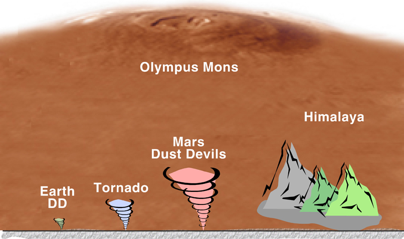
 APOD: 2015 March 3 - A Dust Devil on Mars
Explanation:
It was late in the northern martian spring
when the
HiRISE camera onboard the
Mars Reconnaissance Orbiter spied
this local denizen.
Tracking across the flat, dust-covered
Amazonis Planitia in 2012,
the core of
this whirling dust devil is about 140 meters in diameter.
Lofting dust into the thin
martian
atmosphere, its plume
reaches about 20 kilometers above the surface.
Common to
this region of
Mars, dust
devils occur as the surface is heated by the Sun,
generating warm, rising air currents that begin to rotate.
Tangential
wind speeds of up to 110 kilometers per hour are reported for
dust devils in other
HiRISE images.
 APOD: 2014 March 22 - Martian Chiaroscuro
Explanation:
Deep shadows create
dramatic contrasts between light and dark in
this
high-resolution close-up of the martian surface.
Recorded on January 24 by the HiRISE camera onboard the
Mars Reconnaissance Orbiter, the scene
spans about 1.5 kilometers across a sand dune field in a
southern highlands crater.
Captured when the Sun was just 5 degrees above the local horizon,
only the dune crests are caught in full sunlight.
With the long, cold winter approaching the red planet's southern
hemisphere, bright ridges of
seasonal
frost line the martian dunes.
 APOD: 2014 March 9 - A Hole in Mars
Explanation:
What created this unusual hole in Mars?
The hole was discovered by chance in 2011 on images of the dusty slopes of Mars'
Pavonis Mons volcano taken by the
HiRISE instrument aboard the robotic
Mars Reconnaissance Orbiter
currently circling Mars.
The hole appears to be an opening to an underground cavern, partly illuminated on the image right.
Analysis of this and follow-up images revealed the
opening to be about 35 meters across, while the interior
shadow angle indicates that the underlying cavern is roughly 20 meters deep.
Why there is a circular crater surrounding this hole remains a topic of
speculation,
as is the full extent of the underlying cavern.
Holes such as
this are of particular interest because their interior caves are relatively protected from the harsh surface of Mars, making them relatively good candidates to
contain Martian life.
These pits are therefore prime targets for
possible future spacecraft, robots, and even
human interplanetary explorers.
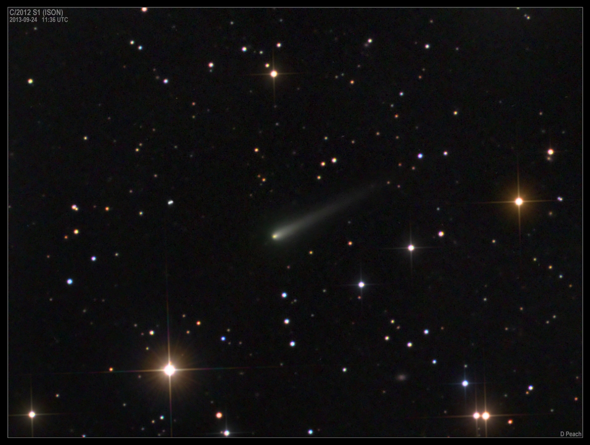
 APOD: 2013 October 7 - Comet ISON Approaches
Explanation:
How impressive will Comet ISON become?
No one is sure, but unfortunately, as
the comet
approaches the inner Solar System, it is
brightening
more slowly than many early predictions.
Pictured above, Comet ISON is
seen about two weeks ago as it continued to develop a tail.
Last week the comet passed relatively close to Mars, and was
directly imaged by the
Mars
Reconnaissance Orbiter.
When Comet
ISON dives to within a few solar radii of the Sun's surface
in late November, it
may become brighter
than the Moon and sport a long and
flowing tail -- or it may appear somewhat less spectacular.
Either way, sky
enthusiasts hope that whatever comet parts survive will put on quite an
impressive show, as viewed from Earth, through at least the rest of the year.
 APOD: 2013 June 17 - Dry Ice Sled Streaks on Mars
Explanation:
What creates these long and nearly straight grooves on Mars?
Dubbed
linear gullies, they appear on the sides of some sandy slopes during Martian spring, have nearly constant width, extend for as long as two kilometers, and have raised banks along their sides.
Unlike most water flows, they do not appear to have areas of dried debris at the downhill end.
A leading hypothesis -- actually
being tested here on Earth -- is that these linear gullies are caused by chunks of carbon dioxide ice
(dry ice)
breaking off and sliding down hills while
sublimating into gas, eventually completely evaporating into thin air.
If true, these natural
dry-ice sleds may well provide
future adventurers a smooth ride on cushions of escaping carbon dioxide.
The above recently-released image was taken in 2006 by the
HiRISE camera on board the
NASA's
Mars Reconnaissance Orbiter currently orbiting Mars.
 APOD: 2013 January 18 - Stickney Crater
Explanation:
Stickney Crater, the largest crater on the martian moon Phobos,
is named for
Chloe
Angeline Stickney Hall,
mathematician and
wife
of astronomer Asaph Hall.
Asaph Hall discovered both the
Red Planet's moons in 1877.
Over 9 kilometers across, Stickney is nearly half the
diameter of Phobos itself, so large that the
impact that blasted out the crater likely came close
to shattering the tiny moon.
This stunning,
enhanced-color image of Stickney and surroundings
was recorded by the HiRISE camera onboard the
Mars Reconnaissance Orbiter as it passed within some
six thousand kilometers
of Phobos in March of 2008.
Even though the surface gravity of
asteroid-like Phobos
is less than 1/1000th Earth's gravity, streaks suggest loose
material slid down inside the crater walls over time.
Light bluish regions near the crater's rim could indicate
a relatively freshly exposed surface.
The origin of the
curious grooves along the surface is
mysterious but may be related to the crater-forming impact.
 APOD: 2012 November 25 - Dark Sand Cascades on Mars
Explanation:
They might look like trees on Mars, but they're not.
Groups of dark brown streaks have been photographed by the
Mars Reconnaissance Orbiter on melting pinkish sand dunes covered with light frost.
The above image was taken in 2008 April near the
North Pole of Mars.
At that time,
dark sand on the interior of
Martian sand
dunes
became more and more visible as the
spring Sun melted the lighter
carbon dioxide ice.
When occurring near the top of a dune,
dark sand may cascade down the dune leaving
dark surface streaks -- streaks that might appear at first to be
trees standing in front of the lighter regions, but cast no shadows.
Objects about 25 centimeters across are resolved on
this image spanning about one kilometer.
Close ups of some parts of this image show
billowing plumes
indicating that the sand slides were occurring even
when the image was being taken.
 APOD: 2012 October 28 - Phobos: Doomed Moon of Mars
Explanation:
This moon is doomed.
Mars,
the red planet named for the
Roman god of war, has two tiny moons,
Phobos and
Deimos, whose
names are derived from the Greek for Fear and
Panic.
These martian moons may well be captured
asteroids
originating in the main asteroid belt between Mars and
Jupiter
or perhaps from even more distant reaches of the Solar System.
The larger moon, Phobos, is indeed seen
to be a cratered, asteroid-like object in this
stunning color image from the
Mars Reconnaissance Orbiter,
recorded at a resolution of about
seven meters per pixel.
But Phobos
orbits so close to Mars - about 5,800 kilometers above the surface compared to 400,000 kilometers
for our Moon - that gravitational
tidal forces
are dragging it down.
In 100 million years or so Phobos
will likely be shattered by stress caused by the
relentless
tidal forces, the debris forming a decaying ring around Mars.
 APOD: 2012 September 10 - Curiosity on the Move
Explanation:
Curiosity is on the move across Mars -- but where is it going?
The car-sized rover's path after 29
Martian days
on the surface is shown on the
above map.
Curiosity is still almost 300 meters from its first
major destination, though, a
meeting of different types of terrain called
Glenelg
and visible on the image right.
It may take Curiosity
two months or so to get to
Glenelg
as it stops to inspect interesting rocks or
landscape features along the way.
The above image
was taken about one week ago from high up by the HiRise camera onboard the robotic
Mars Reconnaissance Orbiter.
 APOD: 2012 August 8 - Curiosity Drops In
Explanation:
Just as it captured
the Phoenix lander parachuting to Mars in 2008,
the HiRise camera onboard the
Mars
Reconnaissance Orbiter (MRO) snapped this picture of the
Curiosity rover's
spectacular descent toward its landing site on August 5 (PDT).
The nearly 16 meter (51 foot) wide parachute and its payload are
caught
dropping through the thin martian atmosphere
above plains just north of the sand dune field that
borders the 5 kilometer high Mt. Sharp in
Gale Crater.
The MRO spacecraft was about 340 kilometers away when the image was
made.
From MRO's perspective the parachute is flying at an angle
to the surface so the landing site itself does not appear below it.
Dangling from tethers and
still about
3 kilometers above Mars, Curiosity and its rocket powered
sky crane have not yet been deployed.
 APOD: 2012 July 18 - A Hole in Mars
Explanation:
What created this unusual hole in Mars?
The hole was discovered by chance on images of the dusty slopes of Mars'
Pavonis Mons volcano taken by the
HiRISE instrument aboard the robotic
Mars Reconnaissance Orbiter
currently circling Mars.
The hole appears to be an opening to an underground cavern, partly illuminated on the image right.
Analysis of this and follow-up images revealed the
opening to be about 35 meters across, while the interior
shadow angle indicates that the underlying cavern is roughly 20 meters deep.
Why there is a circular crater surrounding this hole remains a topic of
speculation,
as is the full extent of the underlying cavern.
Holes such as
this are of particular interest because their interior caves are relatively protected from the harsh surface of Mars, making them relatively good candidates to
contain Martian life.
These pits are therefore prime targets for
possible future spacecraft, robots, and even
human interplanetary explorers.
 APOD: 2012 April 13 - A Dust Devil of Mars
Explanation:
It was late in the northern martian spring
when the HiRISE camera onboard the Mars Reconnaissance Orbiter
spied
this local denizen.
Tracking south and east (down and right)
across the flat, dust-covered
Amazonis Planitia
the core of the
whirling dust devil is about 30 meters in diameter.
Lofting dust into the thin
martian
atmosphere, its plume
reaches more than 800 meters above the surface.
Not following the path of the dust devil, the plume is blown toward
the east by a westerly breeze.
Common in this region,
dust devils occur as the surface is heated by the Sun,
generating warm, rising air currents that begin to rotate.
Tangential
wind speeds of up to 110 kilometers per hour are reported
for
dust devils in other HiRISE images.
 APOD: 2011 September 26 - Dry Ice Pits on Mars
Explanation:
Part of Mars is defrosting.
Around the
South Pole of Mars, toward the end of every Martian summer, the warm weather causes a section of the vast carbon-dioxide ice cap to evaporate.
Pits begin to
appear and expand where the carbon dioxide dry
ice sublimates directly into gas.
These ice sheet pits may appear to be lined with gold, but the precise composition of the dust that highlights the pit
walls actually remains unknown.
The circular depressions toward the image center measure about 60 meters across.
The HiRISE camera aboard the Mars-orbiting
Mars Reconnaissance Orbiter captured the
above image in late July.
In the next few months, as Mars continues its
journey around the
Sun, colder seasons will prevail, and the thin air will turn chilly enough not only to stop the
defrosting but once again freeze out more layers of
solid carbon dioxide.
 APOD: 2011 August 8 - Seasonal Dark Streaks on Mars
Explanation:
What is causing these dark streaks on Mars?
A leading hypothesis is flowing -- but quickly evaporating -- water.
The streaks,
visible in dark brown near the image center, appear in the
Martian spring and summer but
fade in the winter months, only to reappear again the next summer.
These are not the first
markings on Mars that have been interpreted as
showing the effects of running water, but they are the first to add the clue of a seasonal dependence.
The above picture, taken in May, digitally combines several images from the the HiRISE instrument on the
Mars Reconnaissance Orbiter (MRO).
The image is color-enhanced and depicts a slope inside
Newton crater
in a mid-southern region of Mars.
The streaks bolster evidence that water exists just below the Martian surface in several locations, and therefore fuels speculation that Mars might harbor some sort of water-dependent life.
Future observations with
robotic spacecraft orbiting Mars, such as MRO,
Mars Express, and
Mars Odyssey
will continue to monitor the situation and possibly confirm -- or refute -- the exciting
flowing water hypothesis.
 APOD: 2010 November 22 - A Dark Dune Field in Proctor Crater on Mars
Explanation:
Was this image taken with a telescope or a microscope?
Perhaps this clue will help: if the dark forms were
bacteria,
they would each span over football field across.
What is actually being seen are large sand dunes on the floor of
Proctor Crater on Mars.
The above picture was taken by
HiRISE camera
on board the
Mars Reconnaissance Orbiter (MRO),
a robot spacecraft currently in orbit around Mars.
The dark rippled
dunes likely formed more recently than the
lighter rock forms they appear to cover, and are thought to
slowly shift in response to pervasive
winds.
The dunes
arise from a complex relationship between the sandy surface and
high winds on Mars.
Similar dunes
were first seen in Proctor Crater by
Mariner 9 more than 35 years ago.
 APOD: 2010 March 1 - Slope Streaks in Acheron Fossae on Mars
Explanation:
What creates these picturesque dark streaks on Mars?
No one knows for sure.
A leading hypothesis is that streaks like these are caused by
fine grained
sand sliding down the banks of troughs and craters.
Pictured above,
dark sand appears to have flowed hundreds of meters down the slopes of
Acheron Fossae.
The sand appears to
flow
like a liquid around boulders, and, for some reason,
lightens significantly over time.
This sand flow process is one of several which can rapidly change the surface of Mars, with other processes including
dust devils,
dust storms, and the freezing and
melting of areas of ice.
The above image
was taken by the
HiRise camera on board the
Mars Reconnaissance Orbiter which has been orbiting Mars since 2006.
Acheron Fossae
is a 700 kilometer long
trough in the
Diacria quadrangle
of Mars.
 APOD: 2010 January 19 - Dark Sand Cascades on Mars
Explanation:
They might look like trees on Mars, but they're not.
Groups of dark brown streaks have been photographed by the
Mars Reconnaissance Orbiter on melting pinkish sand dunes covered with light frost.
The above image was taken in 2008 April near the
North Pole of Mars.
At that time,
dark sand on the interior of
Martian sand
dunes
became more and more visible as the
spring Sun melted the lighter
carbon dioxide ice.
When occurring near the top of a dune,
dark sand may cascade down the dune leaving
dark surface streaks -- streaks that might appear at first to be
trees standing in front of the lighter regions, but cast no shadows.
Objects about 25 centimeters across are resolved on
this image spanning about one kilometer.
Close ups of some parts of this image show
billowing plumes
indicating that the sand slides were occurring even
when the image was being taken.
 APOD: 2009 November 7 - Stickney Crater
Explanation:
Stickney Crater, the largest crater on the martian moon Phobos,
is named for
Chloe
Angeline Stickney Hall,
mathematician and wife of astronomer Asaph Hall.
Asaph Hall discovered both the
Red Planet's moons in 1877.
Over 9 kilometers across, Stickney is nearly half the
diameter
of Phobos itself, so large that the
impact that blasted out the crater likely came close
to shattering the tiny moon.
This stunning,
enhanced-color image of Stickney and surroundings
was recorded by the HiRISE camera onboard the
Mars Reconnaissance Orbiter as it passed within some
six thousand kilometers
of Phobos in March of 2008.
Even though the surface gravity of
asteroid-like
Phobos
is less than 1/1000th Earth's gravity, streaks suggest loose
material has slid down inside the crater walls over time.
Light bluish regions near the crater's rim could indicate
a relatively freshly exposed surface.
The origin of the
curious grooves along the surface is
mysterious but may be related to the crater-forming impact.
 APOD: 2009 October 21 -Martian Dust Devil Trails
Explanation:
Who's
been marking up Mars?
This portion of a recent
high-resolution picture from the HiRISE camera
on board the
Mars Reconnaissance Orbiter shows twisting
dark trails criss-crossing light colored terrain on the martian surface.
Newly formed trails like these had presented researchers with
a tantalizing martian mystery but are now known to be the work of miniature
wind vortices known to occur on
the red planet -
martian dust devils.
Such spinning columns of
rising air
heated by the warm surface
are also common in dry and desert areas on
planet Earth.
Typically lasting only a few minutes,
dust devils become visible
as they pick up loose red-colored dust leaving the darker and heavier sand beneath intact.
On Mars,
dust devils can be up to 8 kilometers
high.
Dust devils have been credited with
unexpected
cleanings of mars rover solar panels.
 APOD: 2009 March 16 - Martian Moon Deimos from MRO
Explanation:
Mars has two tiny moons,
Phobos and
Deimos.
Pictured above, in a recently release image by
HiRISE camera
onboard the Mars-orbiting
Mars Reconnaissance Orbiter (MRO), is
Deimos, the smaller moon of Mars.
Deimos is one of the smallest known moons in the
Solar System measuring only about 15 kilometers across.
The diminutive Martian moon was discovered in 1877 by
Asaph Hall,
an American astronomer
working at the
US Naval Observatory
in Washington D.C.
The existence of two
Martian moons was predicted around 1610 by
Johannes Kepler,
the astronomer who derived the laws of planetary
motion.
In this case,
Kepler's prediction was not based on scientific principles, but
his writings and ideas were so influential that the two Martian moons are discussed in works of fiction such as
Jonathan Swift's
Gulliver's Travels,
written in 1726, over 150 years before their
actual discovery.
 APOD: 2008 November 24 - Radar Indicates Buried Glaciers on Mars
Explanation:
What created this unusual terrain on Mars?
The floors of several mid-latitude craters in
Hellas Basin on Mars appear unusually grooved, flat, and shallow.
New radar images from the
Mars Reconnaissance Orbiter bolster an exciting hypothesis: huge
glaciers of buried ice.
Evidence indicates that
such glaciers cover an area larger than a city and extend as much as a kilometer deep.
The ice would have been kept from
evaporating into the
thin Martian air by a covering of dirt.
If true, this would indicate the largest volume of water ice outside of the
Martian poles,
much larger than the
frozen puddles
recently discovered by the
Phoenix lander.
Such lake-sized ice blocks located so close to the Martian equator might make a good drinking reservoir for
future astronauts exploring Mars.
How the glaciers originally formed remains a mystery.
In the meantime, before packing up to
explore Mars, please
take a moment to
suggest a name
for NASA's
next Martian rover.
 APOD: 2008 May 30 - Descent of the Phoenix
Explanation:
In this
sweeping view, the 10 kilometer-wide crater
Heimdall lies on the
north polar plains
of Mars.
But the bright spot highlighted in the inset is
the Phoenix
lander parachuting toward the surface.
The amazing picture was captured on
May 25th by the HiRISE camera onboard the Mars Reconnaissance
Orbiter.
Though the lander looks like it might be dropping straight
into Heimdall, it is really descending
about 20 kilometers in front of the crater,
in the foreground of the scene.
The orbiter was 760 kilometers away from Phoenix when
picture was taken, at an altitude of 310 kilometers.
Subsequently the orbiter's camera was also
able
to image the lander on the surface.
The parachute attached to the backshell and the heat shield were
identified in the image, scattered nearby.
Of course, the Phoenix lander itself is
now returning much
closer views of its landing site as
it prepares
to dig into the
Martian surface.
 APOD: 2008 May 27 - Phoenix at Mars
Explanation:
The Phoenix
lander's footpads are about the size of a dinner plate.
One of three is shown
at the right,
covered with Martian soil after
a successful soft landing on the Red Planet
on May 25.
Amazingly, the
left
panel image is of the spacecraft during its descent phase,
captured by the HiRISE camera onboard
Mars Reconnaissance Orbiter --
the first image ever of a spacecraft
descending to the surface
of another planet.
Taken from a range of 750 kilometers, the picture shows Phoenix
suspended beneath its unfurling, 10 meter-wide parachute,
against the much darker Martian surface.
The lander is still attached to its protective backshell.
Phoenix released its parachute at an altitude of
12.6 kilometers.
Using rockets to further reduce its speed for landing,
Phoenix now
rests in the northern polar region of
Mars at about 68 degrees latitude.
 APOD: 2008 May 19 - Flying Over the Columbia Hills of Mars
Explanation:
What it would be like to fly over Mars?
Combining terrain data from the orbiting
Mars Reconnaissance Orbiter
spacecraft with information about the robotic
Spirit rover currently
rolling across
Mars
has resulted in a digital movie that shows
what a flight over the Columbia Hills might look like.
Dark rippled
sand dunes are highlighted against the
Columbia Hills in the above opening image.
Clicking on the
above image,
though, will launch you across Mars, approaching the
Columbia Hills.
On the far side of the hills, the dark sand dunes come into view.
Soon you pass an unusual white-rimmed structure, slightly raised, known as
Home Plate,
the origin of which is currently unknown and being researched.
Turning, you re-approach the hills from a different angle,
this time zooming in on Spirit, a curious alien
rover sent from
planet Earth.
A final zoom pans out over the region.
This coming Sunday,
NASA's
Phoenix Lander
will attempt to set down near the icy
North Pole of Mars
and search for signs of
ancient life.
 APOD: 2008 April 14 - Phobos: Doomed Moon of Mars
Explanation:
This moon is doomed.
Mars,
the red planet named for the
Roman god of war, has two tiny moons,
Phobos and
Deimos, whose
names are derived from the Greek for Fear and
Panic.
These martian moons may well be captured
asteroids
originating in the main asteroid belt between Mars and
Jupiter
or perhaps from even more distant reaches of the Solar System.
The larger moon, Phobos, is indeed seen
to be a cratered, asteroid-like object in this
stunning color image from the
Mars Reconnaissance Orbiter,
recorded at a resolution of about
seven meters per pixel.
But Phobos
orbits so close to Mars - about 5,800 kilometers above the surface compared to 400,000 kilometers
for our Moon - that gravitational
tidal forces
are dragging it down.
In 100 million years or so Phobos
will likely be shattered by stress caused by the
relentless
tidal forces, the debris forming a decaying ring around Mars.
 APOD: 2008 April 10 - Stickney Crater
Explanation:
Stickney Crater, the largest crater on the martian moon Phobos,
is named for
Chloe
Angeline Stickney Hall,
mathematician and wife of astronomer Asaph Hall.
Asaph Hall discovered both the
Red Planet's moons in 1877.
Over 9 kilometers across, Stickney is nearly half the
diameter
of Phobos itself, so large that the
impact that blasted out the crater likely came close
to shattering the tiny moon.
This stunning,
enhanced-color image of Stickney and surroundings
was recorded by the HiRISE camera onboard the
Mars Reconnaissance Orbiter as it passed within some
six thousand kilometers
of Phobos last month.
Even though the surface gravity of
asteroid-like Phobos
is less than 1/1000th Earth's gravity, streaks suggest loose
material has slid down inside the crater walls over time.
Light bluish regions near the crater's rim could indicate
a relatively freshly exposed surface.
The origin of the
curious grooves along the surface is
mysterious but may be related to the crater-forming impact.
 APOD: 2008 April 4 - Layers in Aureum Chaos
Explanation:
At first glance these undulating shapes in shades of blue might
look like waves
on an ocean.
Seen here in a false-color image from the
Mars Reconnaissance
Orbiter's
HiRISE camera, they
are actually layered rock outcrops found in Aureum Chaos.
The larger Aureum Chaos region is a
chaotic jumble of eroded terrain in the eastern part of Mars' immense
canyon Valles Marineris.
Distinct
layers composing these outcrops could have been
laid down by dust or volcanic ash settling from the
atmosphere, sand carried by martian winds,
or sediments deposited on the floor of an ancient lake.
This
close-up view of the otherwise red planet spans
about 4 kilometers, a distance you might
walk over flat ground in less than an hour.
 APOD: 2008 March 11 - An Avalanche on Mars
Explanation:
What caused this sudden cloud of dust on Mars? An avalanche!
The first
avalanche
imaged in progress on another planet was recorded last month on
Mars by
NASA's robotic
Mars Reconnaissance Orbiter.
Visible in the
above picture, digitally rescaled, are several layers of
white ice thawing over red rock,
with darker colors toward the right indicated
Martian soil that mixed with lesser amounts of ice.
As the cliff of over 700 meters high was
thawing,
falling ice crashed down raising plumes of ice and dust so thick they cast
visible shadows.
The scarp has slopes with grades greater than 60 degrees.
The entire scene is illuminated from the upper right by the Sun.
A thaw occurs each spring in the
Northern Hemisphere of Mars, as the warming climate causes solid
carbon dioxide ice to
sublimate directly to vapor.
Studying such avalanches allows planetary geologists to better understand
soil configurations on Mars.
 APOD: 2007 September 28 - A Hole in Mars Close Up
Explanation:
In a close-up
from the
HiRISE instrument
onboard the Mars Reconnaissance Orbiter,
this mysterious dark pit, about 150 meters across,
lies on the north slope of ancient
martian volcano
Arsia Mons.
Lacking raised rims and other impact crater characteristics, this pit
and others like it were originally
identified in visible
light and infrared images from the Mars Odyssey and
Mars Global Surveyor spacecraft.
While the visible light images showed only
darkness within, infrared
thermal signatures indicated that the
openings penetrated deep under the martian surface and perhaps were
skylights to underground caverns.
In this later image, the pit wall is partially
illuminated by sunlight and seen to be nearly vertical,
though the bottom, at least 78 meters below, is still not visible.
The dark martian pits are thought to
be related to
collapse pits in the lava flow,
similar to Hawaiian volcano
pit craters.
 APOD: 2007 May 28 - A Hole in Mars
Explanation:
Black spots have been discovered on Mars that are so dark that nothing inside can be seen.
Quite possibly,
the spots
are entrances to deep
underground caves capable of protecting
Martian life, were it to exist.
The unusual hole pictured above was found on the slopes of the giant Martian volcano
Arsia Mons.
The above image was captured three weeks ago by the
HiRISE instrument onboard the
Mars Reconnaissance Orbiter
currently circling Mars.
The holes were originally identified on lower resolution images from the
Mars Odyssey spacecraft,
The above hole is about the size of a
football field
and is so deep that it is completely
unilluminated by the Sun.
Such holes and
underground caves
might be prime targets for
future spacecraft,
robots, and even the next generation of
human interplanetary explorers.
 APOD: 2007 April 21 - 3D Face on Mars
Explanation:
Get out your
red/blue glasses
and gaze down on this
weathered mesa on Mars.
Of course, described as a rock formation that resembles a human head
in a 1976
NASA press release,
this mesa is also famous as the
Face
on Mars.
The sharp stereo
image was created by
combining high resolution pictures from cameras on two
different spacecraft in Mars orbit -
Mars Reconnaissance Orbiter
and
Mars
Global surveyor.
It shows rugged details of the
approximately 2 kilometer wide, isolated hill - similar
to mesa landforms
on planet Earth - rising
some 240 meters above the plains of the martian
Cydonia region.
This remarkable 3D view exaggerates the hill's vertical dimensions.
 APOD: 2007 February 20- White Ridges on Mars
Explanation:
What created these white ridges on Mars?
The images
showing the white ridges, including some of the highest resolution images
ever taken from Martian orbit, were recorded last year by the
Mars Reconnaissance Orbiter (MRO).
A current
leading hypothesis is that the white ridges formed as water flowed through
underground cracks and bleached and hardened the edges of surrounding rocks.
Over millions of years, surface winds eroded the darker rock leaving the raised white ridges.
Such water-created light-colored markings are well known here on
Earth.
The hypothesis is particularly interesting as underground water
could have helped to support
microbial life on the red world.
The above image resolves surface features as small as one meter across in
Candor Chasma region of huge
Valles Marineris on
Mars.
 APOD: 2006 December 6 - Spirit Rover on Mars Imaged from Orbit
Explanation:
If you have the right equipment, you can see the Spirit rover currently rolling across Mars.
The right equipment, however, is currently limited to the
High Resolution Imaging Science Experiment
onboard the
Mars Reconnaissance Orbiter (MRO).
MRO arrived at
Mars
in March and just started science observations of the red planet last month.
Visible in the above spectacularly high resolution image is the
Spirit rover in the
Columbia Hills of Mars.
Objects as small as one meter are resolved.
Also visible are the tracks made by the
robot explorer and a large plateau of layered rock dubbed Home Plate.
MRO will continue to image the
red planet in unprecedented detail,
creating images that will likely be important in better understanding the
geology and weather on Mars,
as well as indicating good candidate landing sites for
future missions to Mars.
 APOD: 2006 October 9 - Mars Rover at Victoria Crater Imaged from Orbit
Explanation:
An unusual spot has been found on Mars that scientists believe is not natural in origin.
The spot appears mobile and is now hypothesized to be a
robot created by an
intelligent species alien to Mars.
In fact, the spot appears to be NASA's robotic Opportunity rover currently rolling across Mars.
The ability to see the Martian rover from orbit has recently been demonstrated by the
High Resolution Imaging Science Experiment
on NASA's
Mars
Reconnaissance Orbiter (MRO).
The new spacecraft achieved orbit around Mars in 2006 March.
Last week, MRO imaged the location of
Victoria Crater
and the
rover Opportunity that had just arrived there.
In the
above image at spectacularly
high resolution, objects about one meter in size are resolved, and this includes the rolling rover.
Such images may help scientists better determine if any safe path exists for Opportunity to enter large crater.
In the inset image
on the upper left, the whole of
Victoria Crater
was also imaged by MRO.
 APOD: 2006 April 10 - Mars: The View from HiRISE
Explanation:
HiRISE -
the High Resolution Imaging Science Experiment -
rides on the Mars Reconnaissance Orbiter
(MRO)spacecraft
just arrived in Mars orbit on March 10.
This sharp view of
the martian
surface from the HiRISE camera includes
image
data with a full resolution of about 2.5 meters per pixel -
recorded from a range of 2,500 kilometers.
In the coming months,
MRO's orbit will be circularized
through repeated passages into Mars' outer atmosphere,
a process known
as aerobraking, shrinking its orbit
to an altitude of only 280 kilometers.
At that distance, the HiRISE experiment should be able
to image the
Red Planet's surface at a resolution of
28 centimeters (11 inches) per pixel.
In this first color image,
the false colors represent
HiRISE's visible and infrared imaging data combined.
The picture is nearly 24 kilometers wide and covers an
area in the Bosporos Planum region of southern Mars.